
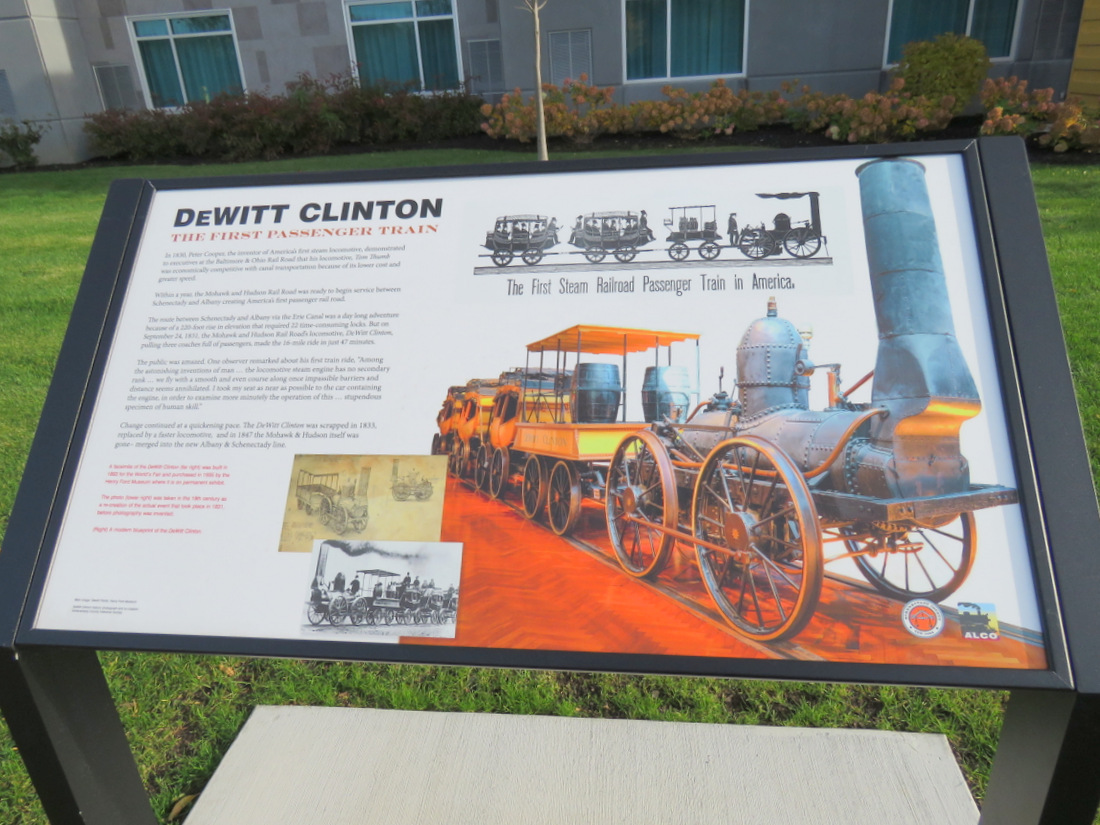
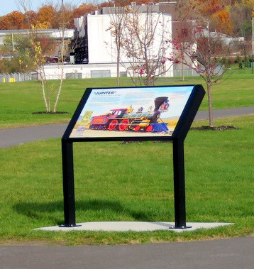
Schenectady County spent $30,000 for a set of “interpretive” signs that were installed along the ALCO Heritage Trail about six weeks ago. They celebrate the proud history of the site as location of the American Locomotive Company, where world-class locomotives and tanks were manufactured for over a century. [See County Press Release (Sept. 18, 2018); Daily Gazette article, and Times Union coverage (Sept. 20, 2018)]
 . .
. . 
But, even a casual look at the placement of the sturdy and wordy signs reveals that they are too close to the bike-hike trail, creating a hazard for anyone stopping to read the lengthy messages, and for bicyclists and pedestrians on the Trail. For example,
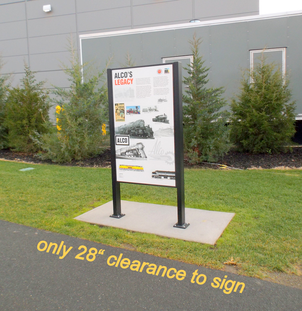
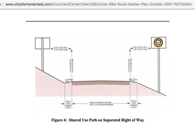
 Neither the required 3-foot lateral clearance from a shared-use path stated in Schenectady’s Bike Master Plans (see below), much less the preferred distance of 3 to 5 feet, has been allotted for the large interpretive signs. The Best Practices rule of thumb of 3-5′ applies even to small signs on single, narrow poles, to help ensure that a cyclist or pedestrian who must swerve off a path in an emergency or panic, has room to maneuver to safety. Instead, the frames of the ALCO Heritage signs are as little 28 inches from the bike-hike path.
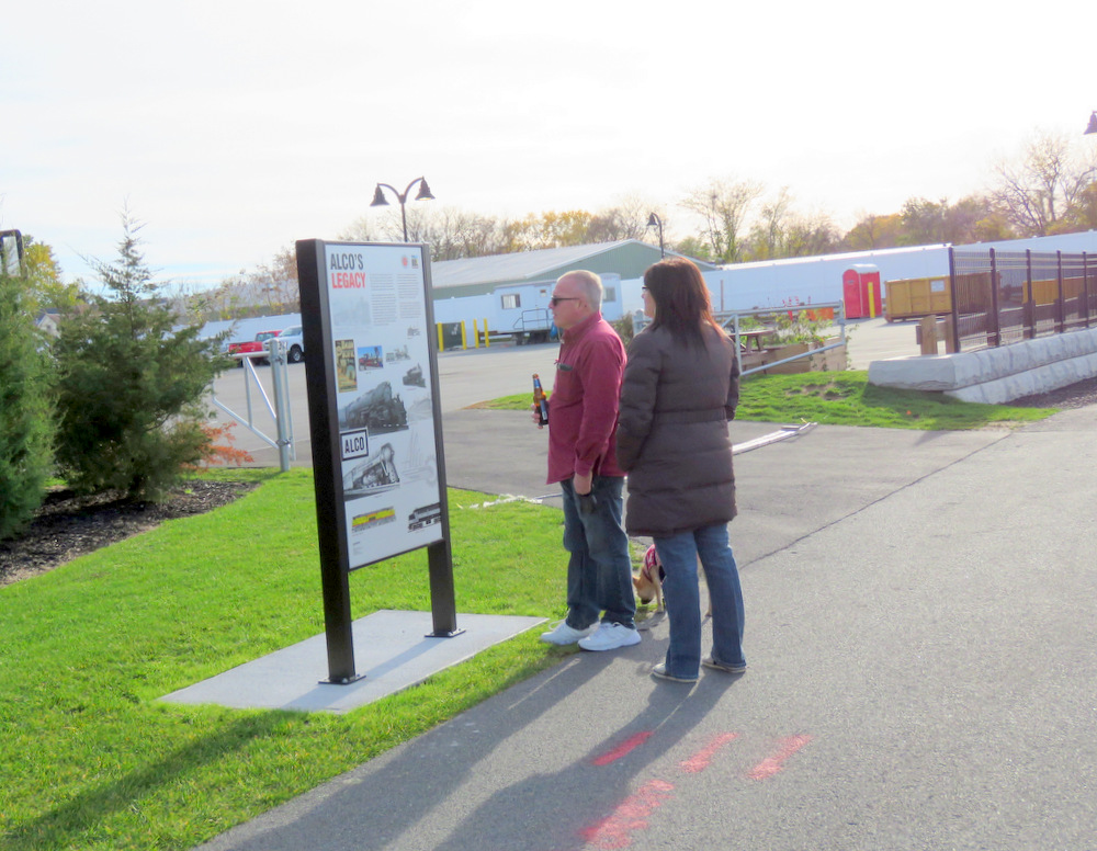
- Whether a reader is alone, or part of a couple, family or group, the only place from which to read each of the 11 signs is from the shared-use Trail, placing them in the way of cyclists, runners, and all types of pedestrians passing by in both directions. The more successful the Trail is attracting users and tourists, the more frequently will conflicts arise.
- There is no hard surface off the path “tread” for sign-readers in a wheelchair, or with a cane, walker or motorized scooter, to stop; nor for a curious bicyclist; nor for pedestrians who want to avoid unpaved ground around the sign when it is wet, slippery, or muddy.
 . .
. . 

Members of the public without planning and engineering degrees (and, surely, even a group of visiting fourth-graders) can immediately see or sense that the ALCO Heritage signs are poorly placed. Why, then, would the County and City of Schenectady, which have been planning and promoting the use of bike and hike trails since before the dawning of the Third Millennium, permit this sub-par (and liability-creating) installation? Good question.
 [R] A new sign is unveiled byGary Hughes, Majority Leader of the County Legislature and Chair of its Economic Planning and Development Committee, and Joe McQueen, Spokesman for the County (Sept. 20, 2018). Photo by Marc Schultz for the Daily Gazette.
 . .
. . 
. . above: [R] Steering Committee for the City of Schenectady Bike Master Plan (2001); and [L] and Advisory Panel of Bike Schenectady Master Plan (2017). Click on image for a larger version.
The County and City both were well-represented on the two Bike Master Plans produced and adopted by the City of Schenectady since the turn of the Century, one in 2001, and one just last year, the Bike Schenectady Master Plan, 2017. [See the lists in the images above this paragraph.] Both Master Plans call for a lateral clearance of at least 3 feet from the edge of the path for any signs along a shared-use path in the City of Schenectady (even small ones on skinny poles). And, of course, in both plans, a shared-use path along the Mohawk at the old ALCO site was seen as the crowning jewel of the system. Click on the images immediately below to see relevant portions of [L] the 2001 Bike Master Plan; and [R] Bike Schenectady (p. B-21 of the Appendices):
 . .
. . 
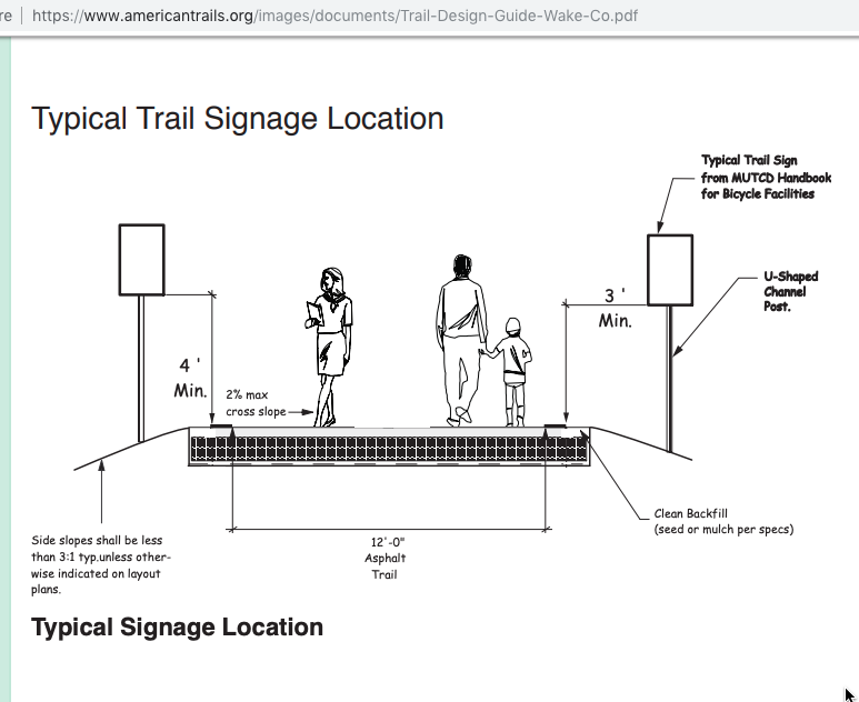
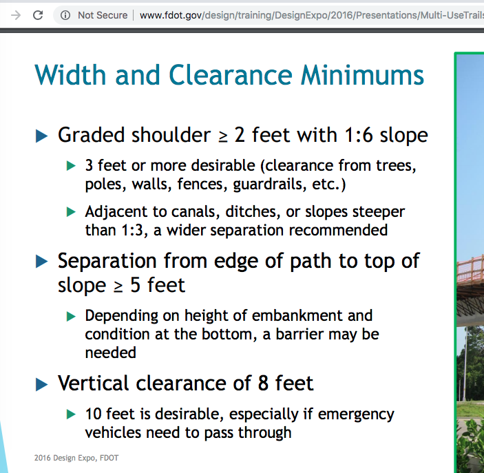
- The American Trails organization also recommends a 3-foot clearance; as does, e.g., the Florida DOT: “3 feet or more desirable (clearance from trees, poles, walls, fences, guardrails, etc.)”.
But, is there any other reason, besides Common Sense safety and convenience concerns, for insisting that those viewing a trail-side interpretive sign be allowed to stand or sit off the trail? The Erie County Wayfinding Manual is a useful guide on many of the issues that arise in planning and implementing a bike-hike trail. It offers the thoughtful guidance that signage formats be “designed around the information they need to convey”, and thus (at 4, emphasis added):
Detailed orientation information, for instance, is placed on large signs where people can pull off the trail and spend as much time as they wish to study made, legends or interpretive information.
It is hard to believe that County and City planning staff members who have been active in municipal bicycle matters are not aware of the notion that interpretive signs be placed in a way that lets interested persons safely study them off the path, on a hard surface. Indeed, only two months ago, the County‘s study for a portion of this very ALCO Heritage Trail, MOHAWK HUDSON BIKE TRAIL EXTENSION FEASIBILITY REPORT (Sept. 14, 2018, at 22), included the following illustration, captioned “Example of wayfaring or interpretive signs”:
 . .
. . 
. . shorter URL for the Sept. 2018 Extension Feasibility Report: https://tinyurl.com/ALCOTrailExtend
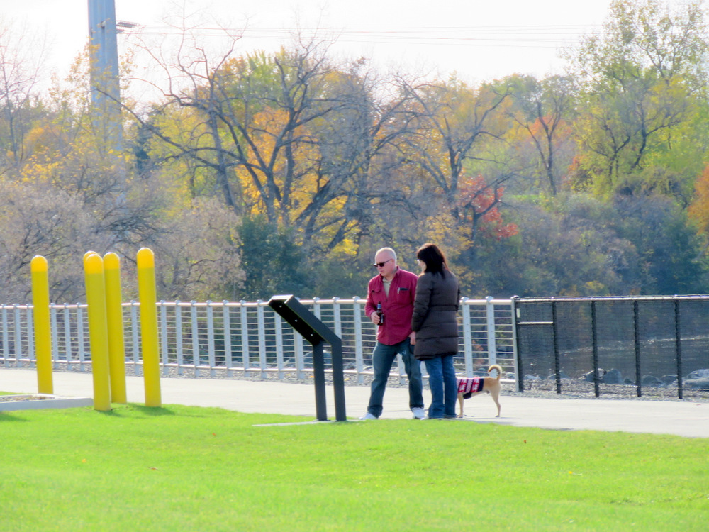
 This past Sunday (Nov. 4, 2018), while standing at the sign shown to the right and speaking to the couple in the photo, speedo-clad bicyclists twice rode quickly past us, appearing from the west, and in no way signaled their presence or their passing us on the left. Over the entire past year walking on the Mohawk Harbor trail and on the only paved path at Riverside Park, only one bicyclist passing me gave the required signal, with the silent ones leaving me startled and often off-balance. If nothing else, the customary behavior of individuals and groups using our trails, along with the lack of enforcement of safety rules, must be taken into account when designing and installing signage.
 My web search could not be exhaustive, but the examples of interpretive signage closer than three feet from a trail that I found, and that were shaped like most of the ALCO Heritage Trail signage (example on the left), were on pedestrian or hiking trails, not trails that were meant to accommodate bicyclists (or horses).
If the experienced and professional staff members in planning and related offices of the County and City are aware of the 3-foot clearance rule and the preference for getting sign-readers off the path, why was the ALCO Heritage Trail signage project so poorly designed? I can only presume that their advice was silenced or over-ridden by people with more authority, who lacked knowledge of the regulation or best practices, and never bothered to ask fundamental questions. Or, who had priorities other than the safety and convenience of trail users, such as using as little of the developer’s or Casino’s lawn next to the path as possible, or spending as little money as possible.
 When I wrote to Metroplex Chair, and County Planning/Development Chief, Ray Gillen, to ask why the signs were so close to the Trail, his only reply on that issue was, “We all think they are beautiful.” Ray Gillen, is known as tireless and working 24/7, and always tells me I should come first to him with concerns. Perhaps others will be more successful than I getting a useful explanation from Mr. Gillen. Maybe, asking Legislator Gary Hughes or Anthony Jasenski, Legislative Chair, would be more useful. My attempts to get answers from City and County leaders have been fruitless, which usually means they know I will not likely like the answer or consider it to be persuasive.
 My hope is that members of the media and general public who care about public safety and transparency, and the rule of law, will probe a bit more. And, do so before the first serious injury along the Harbor Trail, and any related law suit.
Mohawk Harbor was meant to be, and is constantly touted as, the City’s showplace and pride. Yet, the Mohawk Harbor bike-hike trail has been constructed (somehow, at the expense of taxpayers rather than the developer) with little regard for public safety and comfort. Both the history signs on the south/Casino side of the trail, and the guardrails on the riverside of the trail, ignore the City’s codes, policies and plans, as well as best practice guidelines that seem particularly appropriate for our “showplace” Harbor.
. . share this post with this shorter URL: https://tinyurl.com/UnsafeAlcoSigns


